

How people move through the region – whether by car, bus, bike, or on foot – shapes everyday life, economic opportunity, and community safety.
The Rockingham Metropolitan Planning Organization (MPO) works with communities and partners to plan and coordinate transportation investments across 27 municipalities in southeastern New Hampshire. Through collaboration with local, state, and federal partners, the MPO helps guide how transportation investments are planned, prioritized and funded across the region.
This important work ensures that transportation decisions support mobility, safety, economic vitality, and quality of life.
The MPO is the transportation policy making organization for the region. The purpose of the MPO is to administer the federal transportation process and ensure that investments in projects and programs are based on the federally required “3-C” (continuing, cooperative, and comprehensive) planning process.
Primary MPO Functions:
The MPO Prospectus explains how regional transportation planning works in the Rockingham MPO region and who is involved in the process. The prospects serves as a shared reference for communities, agencies, and partners participating in transportation planning.
The Unified Planning Work Program (UPWP) outlines the transportation planning priorities and tasks the MPO will focus on during a two-year period. The document serves as a roadmap for the planning work that supports transportation decision-making across the region.
The Unified Planning Work Program covers:
Archived Unified Planning Work Programs are also located in the RPC Document Library.
Public participation is a vital part of the MPO’s transportation planning process. Community input helps inform decisions, bring forward local concerns, and ensure plans reflect the needs and priorities of the people who live and work in the region.
The MPO actively seeks public input and works with partners, including NHDOT, to balance community priorities with available resources.
Ways to Participate
Commitment to Access and Inclusion
The MPO works to reduce barriers to participate and encourages involvement from underrepresented communities, including low-income residents, people with disabilities, and minority populations.
Technical Advisory Committee (TAC)
Meets monthly (Most Thursdays at 9:00 a.m.)
Stratham Town Offices
MPO Policy Committee
Meets quarterly (2nd Wednesday in January, April, July, October at 7:00 p.m.)
Locations vary
MPO Policy Committee
The MPO Policy Committee provides policy level recommendations, approvals and endorsements relating to the MPO’s transportation planning process.
MPO Policy/RPC Commission meets monthly on the
second Wednesday at 6:30 p.m.
Location varies
| Committee | Date | Agenda | Minutes | Meeting Documents |
|---|---|---|---|---|
| Full RPC Commission, MPO Policy Committee | April 9, 2025 | Agenda | — |



The Transportation Improvement Program (TIP) is a four-year schedule of funded transportation projects planned for implementation across the MPO region. The program shows which projects are moving forward, when they are expected to happen, and how they will be funded.
The TIP is developed collaboratively by RPC, NHDOT, transit agencies, and local communities, and reflects shared regional and state transportation priorities as identified in the State Ten Year Plan. A full description of the TIP development process is in the document.
About Performance-Based Planning (See Appendix B)
Performance-based planning helps transportation planning agencies make better decisions by using data to guide investments and policies. Rather than focusing only on projects, this approach looks at how the transportation system is actually performing – and where improvements will have the greatest impact.
This approach is now required at both the state and regional level under federal transportation law.
IMPORTANT! For the most up-to-date project list and to track TIP revisions, visit the MPO Project Tracker:
Archived UPWP Performance Reports are located in the RPC Document Library
Reference
TIP Amendments are used to address major changes to transportation projects such as significant cost or scope changes, or updates that affect air quality conformity. Amendments may also bundle together smaller administrative updates approved since the last Amendment.
TIP Amendments generally require:
There are currently no pending TIP Amendments.
Minor revisions allow small, non-substantive changes to TIP projects to be made efficiently, without going through the full amendment process. These updates are used when project changes fall within established thresholds and do not significantly affect scope, cost, or air quality.
Types of Minor Revisions
IMPORTANT! For the most up-to-date project list and to track TIP revisions, visit the MPO Project Tracker:
Archived Administrative Modifications can be found in the RPC Document Library
Administrative Modifications from previous TIPs can be provided upon request.
The annual listing of obligated projects report has been a requirement of the federal transportation planning process since TEA-21 was adopted in 1998. This report lists all transportation projects in Rockingham Planning Commission region to which federal funds were obligated during the federal fiscal year.
Obligated projects are organized into two categories:
Regional Transportation Projects: Construction projects in the MPO region that address bridge, roadway, bicycle, and pedestrian improvements funded by the Federal Highway Administration.
Transit Agency Grants: Federal Transit Administration funding provided directly to the three transit agencies in the MOP region to support operations and capital needs.
Previous Annual List of Obligation Projects reports can be found in the RPC Document Library
The Long-Range Transportation Plan looks ahead 20 years to guide how transportation in the Rockingham MPO region will evolve over time. The plan outlines regional policies, goals, and priorities, and specific proposals that support a safe, connected, and reliable transportation system through 2050.
Developed through a collaborative planning process, the plan considers all surface modes of transportation and reflects the shared priorities of local communities, regional partners, and state transportation agencies. It also ensures the region meets federal planning and air quality requirements.
About Performance-Based Planning (See Appendix B)
Performance-based planning helps transportation planning agencies make better decisions by using data to guide investments and policies. Rather than focusing only on projects, this approach looks at how the transportation system is actually performing – and where improvements will have the greatest impact.
This approach is now required at both the state and regional level under federal transportation law.
Long Range Transportation Plans prior to 2050 can be found in the RPC Document Library.
Transportation safety is a top priority for the region. The MPO developed the Regional Safety Action Plan (RSAP) to focus efforts on reducing and eliminating serious injury and fatal crashes affecting all roadway users.
The RSAP is guided by the U.S. DOT Safe System Approach, which focuses on improving safety culture, increasing collaboration across all safety stakeholders, and a refocus on transportation system design on anticipating human mistakes and lessening impact forces. works to improve safety culture
RSAP Commitment to Safety
Resources
The Congestion Management Process (CMP) is a data-driven approach used to understand where congestion occurs and identify the most effective strategies to address it. The goal is to improve transportation planning by directing investments toward projects and strategies that reduce delays and improve system performance.
While CMPs are required in larger metropolitan areas, the Rockingham MPO developed a CMP in 2010 because much of the region lies within the Boston Urbanized Area and experiences similar congestion challenges.
No current information available.
Transportation improvements often begin with right funding opportunity. RPC helps communities identify, pursue, and coordinate grants and programs that support safer streets, improve mobility, bicycle and pedestrian infrastructure, congestion reduction, and long-term transportation planning across the region.
The Congestion Mitigation and Air Quality Improvement Program (CMAQ) is a key source of federal funding available through NHDOT to help communities improve traffic flow, reduce emissions, and expand non-motorized transportation options.
CMAQ is a reimbursement program that provides up to 80% federal funding for local projects with a required 20% non-federal matching funding.
To receive CMAQ funding, municipalities must appoint a project manager who is employed by the city to complete training on NHDOT’s Local Public Agency (LPA) grant management process.
Learn More:
The Highway Safety Improvement Program (HSIP) is a Federal financial aid program administered by the New Hampshire DOT for the purpose of achieving a significant reduction in traffic fatalities and serious injuries on all public roads, including non-State owned roads and roads on tribal land.
The Safe Streets and Roads for All (SS4A) is a competitive grant program with $5 billion in appropriated funds over a period of five years (2022-2026).
The SS4A program funds regional, local, and Tribal initiatives through grants to prevent roadway fatalities and severe injuries. Approximately $1 billion is still available for the next funding round.
Eligible Applicants Include:
Grant Types
Note: A comprehensive safety action plan is the foundation of the SS4A program.
The Transportation Alternatives Program (TAP) is a primary source of federal funding available through NHDOT to help communities improve sidewalks, bicycle routes, rail trails, and other safety projects for people walking and biking. The overall purpose of TAP is to foster non-motorized transportation infrastructure that is safe, in good physical condition, accessible, and capable of reducing traffic congestion.
Program Specifics:
Public transportation plays an increasingly important role in improving mobility, reducing traffic congestion, and supporting air quality in the RPC region. Over the past decade, more communities have gained access to transit services, and ridership has grown in response to rising fuel costs and increasing demand from transit-dependent populations.
Despite this progress, fewer than a quarter of the region’s communities are currently served by public transportation. Expanding service remains challenging due to funding constraints and low-density development patterns making fixed route service inefficient in many towns.
RPC works closely with public transit providers and nonprofit organizations to help expand transportation options and improve access for residents across the region – particularly those serving older adults and people with disabilities.
The RPC region is served by two regional public transit agencies and supported by the University of New Hampshire’s Wildcat Transit service.
Cooperative Alliance for Seacoast Transportation (COAST)
COAST is the public transportation provider in the Seacoast region and provides fixed route transit service in 11 communities including: Exeter, Stratham, Portsmouth, Newington (New Hampshire) and Dover, Newmarket, Somersworth, Rochester, Farmington and South Berwick (Maine).
Greater Derry-Salem Cooperative Alliance for Regional Transportation (CART)
CART is the public transportation provider in the Greater Derry-Salem region, providing demand response and flex route transit service in the RPC communities of Salem and Hampstead, as well as Derry, Londonderry and Chester outside the RPC region. The system also provides service two days per week to five medical facilities in Manchester.
University of New Hampshire Wildcat Transit
UNH’s Wildcat Transit system provides extensive student and employee transportation connection the UNH Duram campus with neighboring communities of Newmarket, Dover, Madbury, Rochester, Newington, and Portsmouth. Wildcat Transit is also open to the general public.
CommuteSMARTseacoast is a Transportation Management Association developed to work with major employers in the greater Seacoast area to promote alternate commuting options.
A program under COAST, CommuteSMART promotes carpooling, bicycling, walking, and telecommuting along with employee incentives. Membership is free and open to any employer in the greater Seacoast region.
Rockingham County has one of the fastest growing senior populations in New Hampshire, making access to reliable transportation increasingly important. Getting to medical appointments, grocery stores, and essential services can determine whether someone is able to age in place or must move into long-term care.
While public transit providers such as COAST and CART serve parts of the region, only a small number of communities have regular transit service. Many towns rely instead on nonprofit and volunteer-based transportation programs. Ongoing needs assessments continue to show that demand for these services is growing.
Transportation Assistance for Seacoast Citizens (TASC)
TASC is a volunteer driver program based in Hampton serving the communities of Brentwood, Exeter, Greenland, Hampton, Hampton Falls, Kensington, North Hampton, Rye, Seabrook and Stratham. Service is available to senior citizens and individuals with disabilities within these communities and destinations outside the region.
Regional Coordinating Councils for Community Transportation (RCCs)
The State of New Hampshire designated a network of ten RCCs to undertake cooperative planning and transit service expansion and development. RPC staff are involved with two of these regional transit development efforts:
The Greater Derry-Salem Regional Coordinating Council for Community Transportation (RCC) is a coalition of organizations with a shared goal of expanding affordable and efficient community transportation in 10 communities in the Greater Gerry-Salem area including: Atkinson, Chester, Danville, Derry, Hampstead, Londonderry, Plaistow, Salem, Sandown, and Windam.
The RPC is a member of the RCC.
Purpose of the Regional Coordinating Council:
The RPC region benefits from an excellent network of publicly subsidized intercity bus and rail services. These include:
RPC staff has a limited role with intercity service. Staff provides assistance to the Exeter Downeaster Station Committee and has assisted each of the intercity providers with demographic analysis related to Federal Transit Administration (FTA) reporting requirements.
Improving safety for people walking and biking – and making it easier to take short trips without a car – is a priority for the RPC. More than 22% of daily trips in the U.S. are less than one mile, a distance that can often be walked or biked.
For decades, transportation systems have been designed primarily for vehicles, often overlooking the needs of people walking or cycling. This has contributed to safety concerns, poor air quality, and public health challenges. In response, many communities in the RPC region have taken steps to become more bicycle- and pedestrian-friendly by launching Safe Routes to School programs, investing in sidewalks and bike lanes, and building multi-use trails.
RPC supports this work using the “Five Es” approach:
RPC staff collaborate with municipalities, NHDOT, the State Trails Bureau, and nonprofit partners such as Seacoast Area Bicycle Riders (SABR) and the Bike/Walk Alliance of New Hampshire to improve safety and expand walking and biking options across the region.
U.S. Bicycle Route 1
Follows NH Route 1A and 1B 22 miles from Seabrook to Portsmouth.
Great Bay Bicycle Loop
This initiative is intended to connect the communities of Portsmouth, Greenland, Stratham, Newfields, Newmarket, Durham, Madbury, Dover, and Newington with a safe on-road route for bicycle commuting or recreational riding.
Planning safe, connected bicycle networks can be challenging – especially in smaller and rural regions where detailed data is often limited. To address this, RPC partnered with New Hampshire’s other Metropolitan Planning Organizations, the Central NH Regional Planning Commission, and Plymouth State University on a Federal Highway Administration (FHWA) pilot project.
Project Purpose
The BLTS Pilot Project helped develop a shared, data-driven approach to:
What Is Bicycle Level of Traffic Stress?
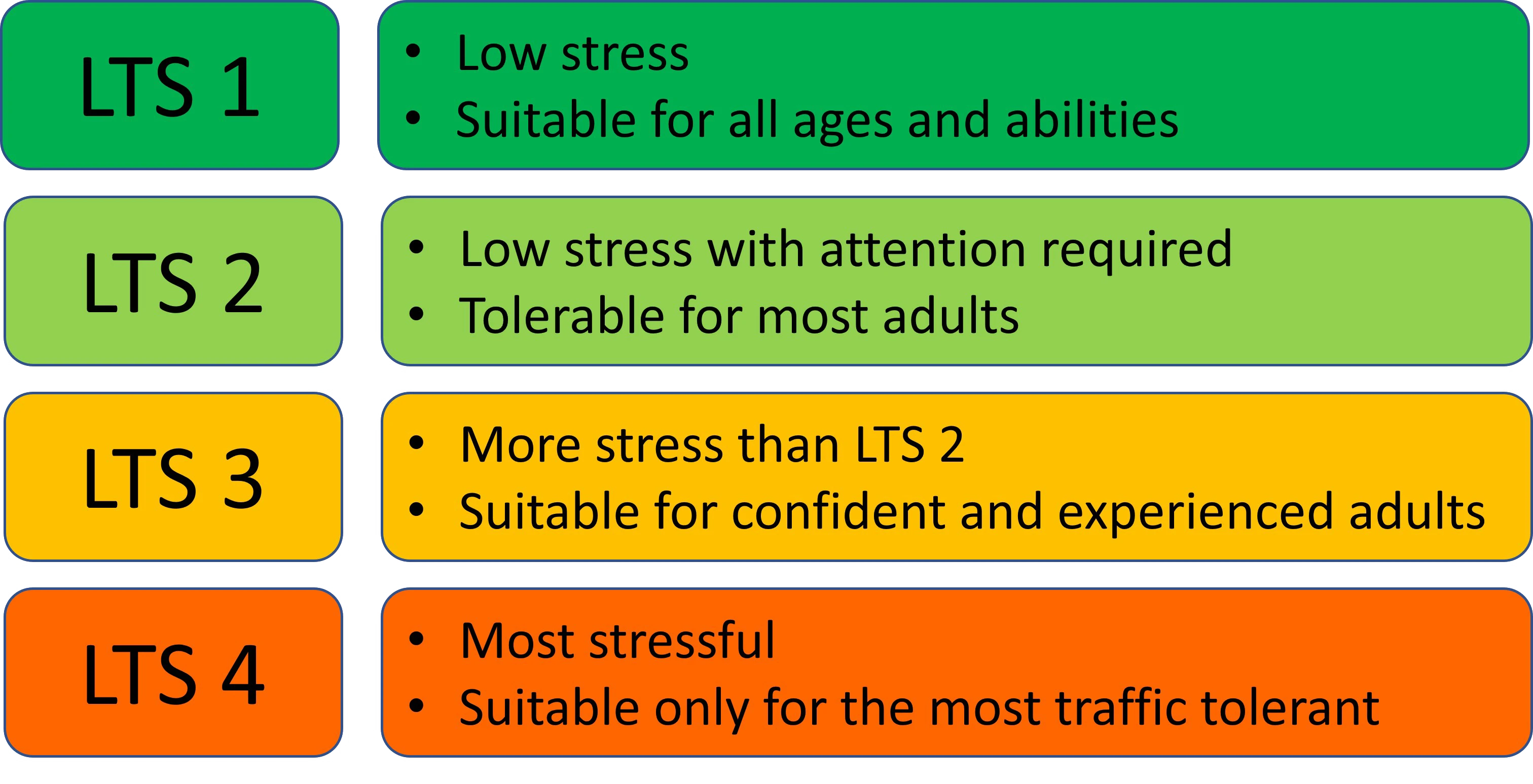
Bicycle Level of Traffic Stress (BLTS) measures how suitable a roadway is for bicycling, recognizing that people have different comfort levels when riding near traffic. Lower stress routes are generally more comfortable and accessible to a wider range of riders.
How the Project Worked
Why It Matters
The project helps communities:
The mission of the NHDOT Complete Streets Advisory Committee is to support bicycling, walking, and transit as safe, convenient, and sustainable forms of transportation that increase New Hampshire’s livability, increase economic activity, and improve public and environmental health.
The SCAC seeks to improve the state through education, public outreach, collaboration, policy, and construction.
SCAC projects include:
Former railroad corridors across the RPC region are being transformed into multi-use trails that support walking, biking, recreation, and regional connectivity. Together, these trails form the foundation of a growing network that links communities, outdoor destinations, and economic centers.
The RPC supports regional trail planning efforts to connect local paths into a cohesive, interconnected trail system – making the region more accessible, active, and attractive for residents and visitors alike.
New Hampshire Seacoast Greenway (East Coast Greenway)
RPC leads regional planning for the New Hampshire Seacoast Greenway, the state’s segment of the East Coast Greenway – a nearly 3,000-mile trail connecting communities along the eastern seaboard from Canada to Key West.
The Seacoast Greenway is envisioned as a safe, accessible community asset for:
RPC works with a regional advisory committee and local partners to support trail design, funding strategies, management planning, and volunteer stewardship.
Seacoast Trails Initiative
Building on the Seacoast Greenway, this initiative will use the NH Seacoast Greenway as a trunk route to connect multiple local trail networks used by walkers, mountain bikers, and equestrians to form an interconnected regional network.
Southern New Hampshire Rail Trail
Located in western Rockingham County, this trail runs from Salem north through Windham, Derry, and Londonderry, with plans to connect to a statewide trail network. RPC has supported early planning efforts, including helping the Town of Salem secure funding for trail engineering.
Rockingham Recreation Trail
The Rockingham Recreation Trail extends more than 26 miles from Newfields to Manchester, with additional segments managed by the State Trails Bureau. While RPC is not directly involved in planning this trail, there is growing interest in strengthening connections between Seacoast trails and the Manchester region.
Since 2003, the RPC has worked with area businesses, municipalities, UNH, SRPC, and Seacoast Area Bicycle Riders (SABR) to organize regional events for National Bike/Walk to Work Day.
Held annually on the third Friday of May, Bike/Walk to Work Day is designed to create a fun occasion to encourage commuters to try walking or biking to work in a supportive way.
Past events have engaged hundreds of commuters and dozens of companies, helping eliminate thousands of vehicle miles and pounds of CO₂. Portsmouth, in particular, has seen dramatic growth in bicycle commuting, increasing 537%* between 2000 and 2013.
*(U.S. Census, League of American Bicyclists.)
The goal of the Safe Routes to School (SRTS) program is to encourage more kids in grades K-8 to walk or ride bicycle to school, and ensure that they can do so safely.
Seven communities in the RPC region have established SRTS programs including:
SRTS programs use a multi-pronged approach known as the “5Es” – Engineering, Education, Encouragement, Enforcement, and Evaluation.
RPS staff have assisted multiple communities with initiating SRTS efforts, securing SRTS startup or travel planning grants from NHDOT, and developing SRTS Travel Plans.
School zone safety projects remain a high priority for Transportation Improvement Program (TIP) funds. RPC staff are available to assist member communities with developing SRTS efforts.
Transportation has always shaped where and how communities grow. By providing access to land, each major shift in transportation has influenced settlement patterns across the region.
Key moments in transportation evolution:
Together, these transportation systems have shaped the region’s physical layout and continue to influence how communities grow, connect, and function today.
The New Hampshire Department of Transportation (NHDOT) is responsible for the management and implementation of all projects on State highways and ultimately for all projects utilizing federal funds.
Corridor studies examine how key roadways function today—and how they can better move people and goods in the future. These studies help identify practical transportation improvements while balancing community priorities, safety, and available funding.
RPC and NHDOT use corridor studies to inform the Long Range Transportation Plan, Transportation Improvement Program, and the State Ten-Year Plan.
US Route 1 – Hampton Falls (2022)
This study evaluated options to address congestion through the Hampton Falls town center. Public input played a key role in shaping the outcome, with the community expressing a clear preference against widening the roadway. As a result, the study prioritizes alternative strategies to improve traffic flow and safety.
US Route 1 Corridor Plan
This long-term plan provides a shared vision for the Route 1 corridor based on updated traffic data, growth assumptions, and strong local input. The goal is to improve safety and mobility while better integrating the roadway into surrounding communities—rather than allowing it to divide them.
The plan serves as a flexible blueprint to guide future transportation and land use decisions along the corridor.
NH Route 125 – Epping to Rochester
This comprehensive transportation and land use study identified recommended improvements along the Route 125 corridor, including the RPC community of Epping. The study supports coordinated planning across municipal boundaries.
Earlier Corridor Studies
Printed copies of older studies are available for review at the RPC office, including:
These studies provide historical context for how transportation planning in the region has evolved.
The RPC region is home to three state-designated Scenic Byways – roadways recognized for their scenic beauty, historic significance, and cultural value. Scenic Byways celebrate places worth slowing down for, while supporting tourism, local economies, and community-led stewardship.
The Scenic Byway program is not regulatory. Instead, it encourages collaboration among communities to protect and enhance the qualities that make these routes special.
New Hampshire Coastal Byway
Running 22 miles along Route 1A and Route 1B from Seabrook to Portsmouth, the NH Coastal Byway showcases sandy beaches, rocky shoreline, salt marshes, state parks, and historic coastal communities. It also serves as a state and national bicycle route, carrying U.S. Bicycle Route 1 and the East Coast Greenway.
RPC completed a Corridor Management Plan in 2015 and continues to support regional coordination and implementation efforts.
Robert Frost / Old Stage Coach Scenic Byway
This byway follows the historic Boston–Haverhill–Concord stagecoach route through Atkinson, Hampstead, Chester, Auburn, and Derry. It highlights the landscapes, historic sites, and rural character that inspired Robert Frost and shaped early New England travel.
RPC partnered with the Southern NH Planning Commission (SNHPC) and local communities to secure designation, establish a byway council, and complete a corridor management plan.
American Independence Byway
Stretching through Exeter, Hampton, Hampton Falls, and Kensington, this byway tells the story of New Hampshire’s colonial and Revolutionary-era history. Highlights include early settlement sites, preserved agricultural landscapes, and the American Independence Museum in Exeter.
While the byway remains designated, there is currently no active byway council.