Scenario Planning
Scenarios, in the realm of transportation and land use planning, are organized sets of assumptions that explore the ways in which a region might change and grow in the future. They provide a structure to envision potential needs as well as possible future policy and investment options. By analyzing various demographic and land-use changes at the community and regional levels, stakeholders can better understand how these forces may potentially impact the overall scale and distribution of development in a region; through that, the impacts on transportation networks, housing needs, the environment and other areas. There are many ways to implement scenario planning, however, there are several key elements that should be included in all cases:
- Use of scenarios to compare and contrast interactions between multiple factors, such as transportation, land use, and economic development.
- Analysis of how different land-use, demographic, or other types of scenarios could impact transportation networks or other systems.
- Identification of possible strategies that lead toward achieving desired elements of the future conditions examined.
- Public engagement throughout the process.
As part of the 2014 update to the Regional Master Plan, a scenario planning exercise was conducted to examine the potential impacts of different amounts of growth and distributions of that growth on land use, economics, and the transportation network in the region. Utilizing the regional travel demand model, supplemented with a GIS-based regional buildout analysis, and the Economic and Labor Market Information Bureau’s New Hampshire Econometric Mode, four scenarios were compared; baseline 2010, slow growth 2040, strong dispersed growth 2040, and strong concentrated growth 2040.
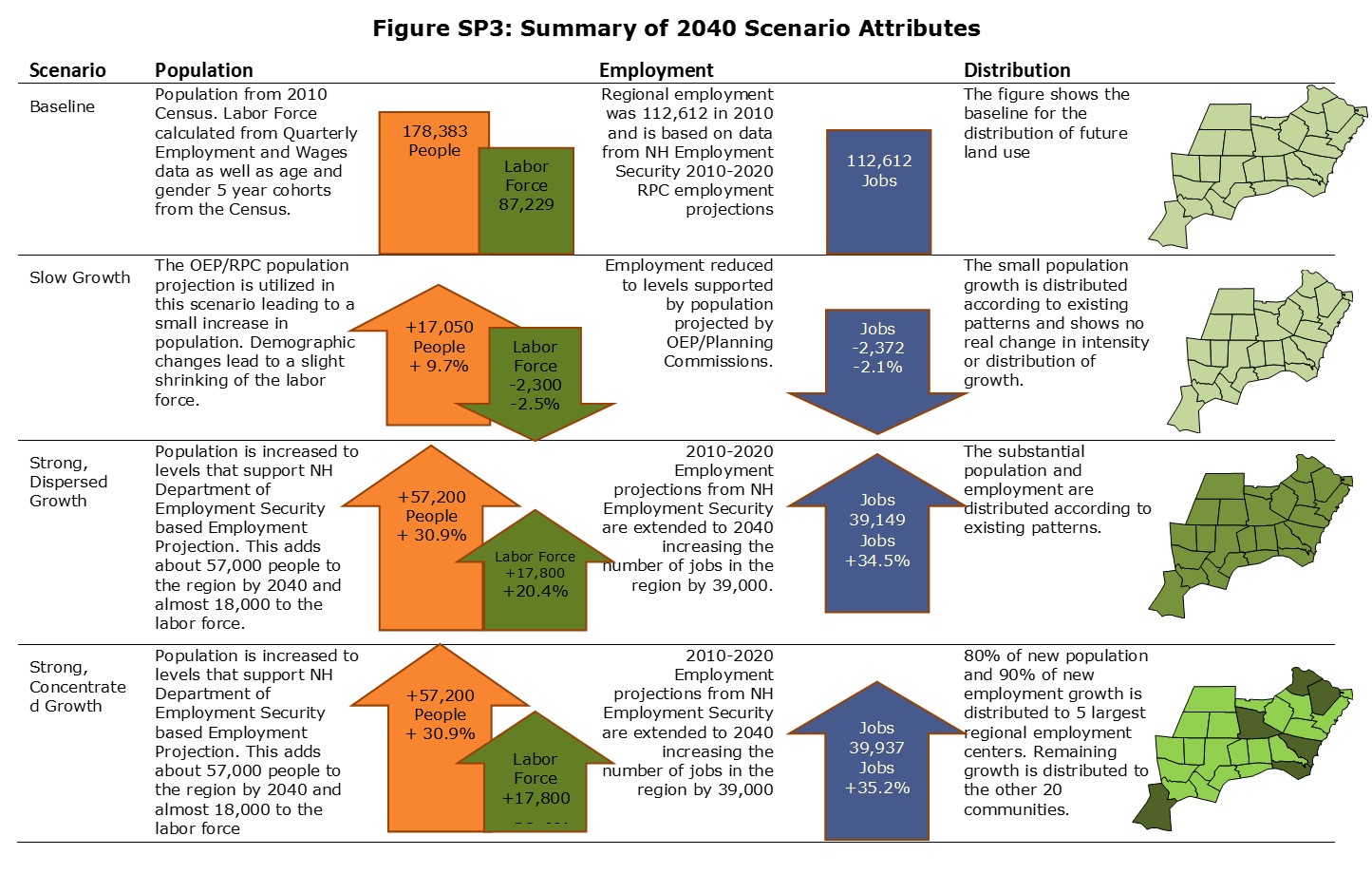
By most measures, the slow growth scenario produces the smallest impacts on the transportation system with the lowest delay and amounts of congestion. However, the economic implications of that scenario would also indicate that it is not a desired future for the region. Some of those impacts by 2040 are:
- Overall lower employment than 2010
- Smaller work force than in 2010.
- The NH Econometric model suggests that there would be $4.2 billion per year less in the regional economy due to the smaller amount of employment in the region compared to the higher growth scenarios.
- $2.5 billion less in personal income in the region.
- Fewer jobs within a 15 minute commute than exists now in many communities.
- The concentrated development scenario fits generally within densities and development levels allowed by current zoning standards in the region.
- The concentrated development scenario produces population and population densities in both the regional employment centers and in all other communities that are higher than they are today.
- The concentrated development scenario shows modest growth in the more rural communities which allows them to better maintain their character without sacrificing economic growth.
- Focusing 90 percent of all new employment into the five employment centers increases the share of regional employment that those areas have by only four percent (74 to 78 percent).
- Focusing 80 percent of the new residential growth to the employment centers substantially increases the share of population that those communities have from 49.5 percent to almost 60 percent. This may have further benefits for the region from expanded services and economies of scale.
- Benefits of concentrated employment and housing as compared to a dispersed growth pattern:
The two scenarios that measure substantial growth were not compared directly in the econometric model as it looks at the level of economic activity at a regional level and not the geographic distribution within the region. However, the concentrated population and employment pattern results in the best outcomes in terms of efficient use of land and the transportation system as modelled in the Regional Buildout and the Regional Travel Demand Model.
- Less Vehicle Miles of Travel overall.
- Decreased Vehicle Miles of Travel on a per capita basis
- Shorter trips of all purposes in both time and distance
- Increased numbers of non-motorized trips
- Less congestion and delay during peak hours
The full analysis can be found in the Regional Master Plan Scenario Planning chapter.
Link to Regional Master Plan Scenario Planning Chapter
As part of the 2015-2016 update to the Long Range Transportation Plan the above scenarios will be expanded to include strong population growth occurring outside of the RPC region while strong employment growth continues within the region to better examine the impacts of commuting into the region.

